 |
| This was Lelia and I after sitting in traffic somewhere in Northern Virginia. (Day of the Dead candles from a Mexican restaurant in Shepardstown, WV) |
Last evening my daughter Lelia and I returned home from a week long visit to Civil War battlefields in the Eastern United States. It was a great way to have some father-daughter time together. It was even more joyful to see how Lelia looked at things for the very first time, such as the Gettysburg battlefield or the nation's capital building and mall. She had never been to Washington DC before.
Along the way there were many moments of fun, but also a few moments of terror, desperation and frustration. The terror consisted of driving through the mountains of Pennsylvania, along the Pennsylvania Turnpike, in a blinding rain storm with limited visibility. The desperation was fighting our way through the horrible traffic around WDC and Fredericksburg. If I never see Fredericksburg again, I'm good. Drivers in Northern Virginia seem to take great delight in such things as forcing you off of the road in a lane merger or speeding up to prevent you from changing lanes.
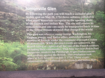
The frustration was sitting at a two hour dead stop somewhere in the middle of Ohio, waiting for a vehicle accident to be cleared away. Frustration was also symobolized by the idiotic GPS system that kept sending us back to Jumonville Glen over and over and over and over again. Sheesh! At one point the GPS tried to steer us onto I95 heading north from Fredericksburg towards WDC on a late Sunday afternoon. I knew enough not to get into that one, but I still got stuck in a 45 minute wait to travel the one mile needed to get onto US17 and freedom.
 |
| Flippin' Jumonville Glen |
We made it a two day drive from Chicago to Gettysburg, stopping near Cleveland, Ohio at the end of the first day. One the second day, I thought that it would be a good idea to visit Fort Necessity and Fort Ligonier for a couple of side trips along the road to Gettysburg.
I should mention that my car has its own GPS navigation system that works just fine, but it has a feature called Apple Car Play that allows the evil Siri to take over the navigation system and inflict her own sense of macabre evil on us unsuspecting travelers. Once Siri and Google Maps takes over, it is seemingly impossible to turn it off and get back into the onboard vehicle GPS system. It might work out OK other than the fact that Siri decided, quite frequently, that "something is wrong, please try again". After hearing this for the umpteenth time, I very nearly chucked my iPhone out the window.
So the first indication of trouble came when I decided to get off of the Penn Turnpike and visit Fort Necessity. The national park has built a reproduction of George Washington's ramshackle fort and has a good visitors' center. I thought that this would serve Lelia as a good introduction to the French and Indian War. Apparently, Jumonville Glen is a part of the Fort Necessity National Battlefield Park and no amount of coaxing or persuasion could compel Siri to give us directions to Fort Necessity. We kept going around and around and ending back at Jumonville Glen. OK JG, I'm done with you (as Joe Pesci might say).
 |
| Lelia and I after waiting all afternoon to get proper directions to Fort Necessity. |
Finally I decided that enough is enough and gave up on finding Fort Necessity and move on to Fort Ligonier. Guess what? We had wasted so much time trying to find the former that the latter would be closed by the time we got there (at 3PM according to my iPhone). As it turned out, the actual closing time of Fort Ligonier was 5PM and we could have made it with time to spare.
I didn't need Siri to find my way back to the Pennsylvania Turnpike so there we went and had fun driving through all of the tunnels. The next mission was to exit the turnpike at the road to Chambersburg and then on to Gettysburg, where we would spend two nights and three days. I made the right exit, but the evil Siri (Siri, I hate you) told me to take a left turn off of the turnpike rather than a right turn. My sense of direction told me that I should make a right turn, but then I hadn't yet become wise to the teasing and taunting ways of Siri.
So against my better judgement, I took the left turn instructions, and after several miles on some small country road, the GPS directed me to turn into a residential neighborhood and make all manner of twists and turns. Ultimately Siri sent me back to the Pennsylvania Turnpike. Well I might not be the sharpest knife in the drawer, but even I could figure out that it was time to implement the George Costanza Method of GPS Travel. If Siri told me to go in one direction, I would go in the opposite direction. If she told me to make a left hand turn, I would continue to go straight on down the road.
My sense of direction got us to Chambersburg with relative ease now that I was no longer listening to Siri. Chambersburg is a larger city than I remember and I kept thinking that it was about time that we reached the intersection with US30, which runs directly into Gettysburg as the Chambersburg Pike. Lelia was sure that I had no idea of what I was doing, but I held my ground and told her that I was driving south no matter what because eventually the road had to intersect with US30, and it did. The lesson here is to follow your instincts and your familiarity with the history of the battlefield. Siri is not your friend.
We finally crested one of the ridges to the west of Gettysburg and this is what we saw:
 |
| McPherson's Ridge and Barn. The ground of the first day's battle of Gettysburg. |
 |
| Hall's Maine Battery and the equestrian stature of General Reynolds. |
 |
| The statue of Sam Elliott, erm, I mean John Buford |
 |
| The Chambersburg Pike at McPherson's Ridge. It was the best damn ground that I've seen all day. |
Seeing McPherson's Ridge at last, I turned to Lelia and said, "this is good ground to fight." She replied, "it's the best damn ground that I've seen all day."
Oh, I forgot to mention why Fredericksburg is such a pain in the neck to drive through. We were doing the Four Battlefields In One Day Tour (Fredericksburg, Chancellorsville, The Wilderness and Spotsylvania Courthouse) and at the end of the day I decided to retrace my steps and return to Warrenton (where we were staying) via US17.
Bad move Bonzo.
Had I looked at a map, I would have driven west on the Orange Turnpike to Culpepper and then jogged north into Warrenton, probably an easy 30-minute drive. We would have passed through Brandy Station along the way too. Not only was it more distance to go back to F-Town to pick up US17, but we also got stuck in a traffic jam trying to cross the Rapahanock Bridge. A simple one mile distance took us 45 minutes to traverse.
Still, we had a lot of fun and that's what it is all about. I will post four or five more posts about our trip so that I can devote individual posts to our visits to the respective battle field sites.


Sounds like a wonderful trip, Siri and traffic notwithstanding. Your daughter clearly has a rapier wit too. I just love her McPherson's Ridge retort.
ReplyDeleteBest Regards,
Stokes.
Gettysburg is such an amazing place. When we were last there, my wife and daughter went on a "ghost tour" of the battlefield at night. (I didn't have the courage.) they said it was creepy as all-get-out.
ReplyDeleteThank you for sharing this. Sounds like a outstanding time was had by the both of you.
ReplyDeleteGreat trip so memorable for both your daughter and yourself. I look forward to hearing more.
ReplyDeleteGettysburg is on my todo list. The traffic/travel problems you describe wouldn't leave me in a jolly mood though!
ReplyDeleteP
Traffic around Gettysburg is easy peasy, so don’t let that deter you from making a visit.
DeleteTwo words: map book! I never leave home without it. GPS is my backup. I have been to Gettysburg once and was going to try to walk the field in 100 degree weather. Luckily my wife talked me out of that!
ReplyDeleteI had a Rand McNally road atlas on hand but it didn’t show Fort Necessity on the map. I should have consulted the RM map around Fredericksburg.
DeleteI am old/sad enough to require a paper car atlas in each car. A minute or two with it is usually enough to get my bearings. However some of these travel apps are v useful. A couple of weeks ago we were stuck in a nightmare jam on the M25 just south of London stretching for tens of miles. Thankfully we managed to get off and the app took us via the back roads almost all the way home. You do see bits of south London you never knew existed. Somehow keeping moving, even at a crawl is better than sitting stationary.
ReplyDeleteGuy
PS I look forward to the further installments.
I wish that I’d had the Wayz app to avoid the traffic.
Delete"It's the best damn ground that I've seen all day." - Priceless!
ReplyDeleteI look forward to you sharing more of your adventures. Thanks for sharing.
My wife and I made almost the identical trip about three years ago. We flew into Baltimore rented a car. Stated at a B&B at Antietam. Two days later we went to Gettysburg and stayed at the Federal Point Inn for three days.
ReplyDeleteI absolutely agree with you that Antietam is virtually a virgin battlefield. It isn't as crowed ed with people or monuments which IMO clutters up the battlefield.